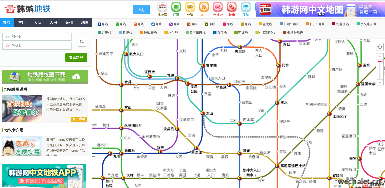
Seoul metro map, South Korea metro line map, Chinese version, Busan metro line map, South Korea
Tag: metro map
Chinese Websites: http://ditie.hanyouwang.com/ Enter The Website
The Chinese version of Korean subway route map of hanyou.com provides the subway information of Seoul, Busan, Daejeon, Daegu and other regions. As long as you choose the starting point and destination of the subway, the best route you can take includes the required time, cost, transfer times, total station number and other details, which is very convenient and practical!

Seoul Metro is the world's top five largest subway system with the highest passenger capacity. It is located in Seoul, the capital of South Korea, with a capacity of up to 4 million passengers a day. There are 19 routes serving the capital circle of Seoul and the surrounding Gyeonggi road.
Use Metro query method:
- Click the starting station and terminal station to automatically calculate the shortest distance, time and fare;
- Click the direction key in the upper left corner or press and hold the mouse on the map to move freely; click the zoom in and zoom out key in the upper left corner or roll the mouse wheel to zoom in and zoom out freely to maintain ultra-high definition.
Seoul Metro mainly consists of underground railways, supplemented by the lines of the Korean railway commune, such as the Bantang line and Incheon metro, etc., totaling 19 lines, serving the capital circle of Seoul and the surrounding Gyeonggi road. The first route was built in 1974. At present, the ticket price starts from the basic 12 km 1050 won, an increase of 100 won per 6 km. At present, Seoul Metro is operated by two companies: Line 1 to line 4 is operated by Seoul Metro commune, while line 5 to line 8 is operated by Metro commune. In addition, national railway also operates line 1 and line 3.


